 Starting out
Total climb: 7.9 miles (41700 feet)
Average distance per day: 42.2 miles
Average climb per day: 1737.5 feet
Average speed: 8.4 mph
Punctures: Paul 4, Ann 1
Broken chains: Paul 2, Ann 1
Buckled wheels: Paul 1, Ann 0
Broken pumps: Paul 1, Ann 0
Broken spokes: Paul 1, Ann 0
Bikes: Claud Butler tourers, 1 'Majestic', 1 'Majestique' (mixte frame). Both have been customised over the years, in particular by upgrading the transmissions to 18-speed gearing with a mountain-bike type range. We've got Blackburn style back racks and front low riders. We each carried back and front panniers and a camera bar bag. Sleeping bags, cooking equipment etc, as well as our clothes fitted in the panniers. Paul carried the tent and Ann carried the sleeping mats on the back rack.
Paul Smee is American, 47 years old at the time of our trip. He was born in Little Rock, Arkansas, raised in Pittsburgh, Pa, and spent 16 years in Boston, Ma, before coming to Bristol to work in the University Computing Service in 1980.
Ann French is a Scot, 48 years old at the time of our trip. She was born in Aberdeen and brought up in Aberdeenshire. After Aberdeen University, she went first to Exeter then got a job in the University of Bristol Computing Service in 1970. She spent 1972-5 in London but returned to Bristol where she has been ever since.
We took many photos during the trip but only two have been scanned:
[Paul] - We had been planning to make this trip for a long time, and late last year we applied for a month of unpaid leave this summer, to do it. The theory was that we would need some large part of that, and then Ann's mum would never forgive us if we got all the way to Scotland and didn't visit, so we'd need some time for that. In February, Ann damaged a knee ligament in a skiing accident, and we thought we would have to cancel. However, by May it seemed that she'd probably be able to manage the trip. Her physiotherapist suggested that the exercise would fit in with her rehabilitation, so we decided to chance it. We dug out our maps and roughed out a route.
The trip was planned as a camping trip, so we checked over our equipment. A bit of research indicated that a new tent was probably in order - we could get one which would be larger when up, smaller when packed, and lighter, than our old Ultimate Phasar Dome. We decided on a Vaude Orbit 2, which had two entrance bells, giving some undercover space for stowing the luggage. We also bought a pair of 'Ridge Rest' mats, which were lighter, and packed smaller, than our old flat mats, and, it turned out, were also more comfortable. (Thanks for the hint, Judy.) We also bought a pair of cloth water bottles, which did dual duty, carrying extra water during the day, and as pillows at night.
[Paul] - Because of Ann's knee injury, we hadn't actually been out on the bikes all year. We had been working out in the gym, though, so we thought that we were reasonably fit. [Ann: Paul may have been reasonably fit - I thought I could make it as far as Temple Meads to catch the train.] However, finally we decided that it might be a good idea to try a little spin. It was a disaster, as Ann couldn't get her knee to bend enough to get the pedals over the top of their spin without an impractically long warmup. We determined that she could spin OK if she put her foot too far forward on that pedal, so we tried removing the toe clip, but her platform pedals were too slippery to use without straps. In the end we put on a cheap set of rubber-block pedals which did the trick, even if they were inelegant.
Statistics: 12.7 miles, 8.9 mph, climb 680 feet, 53.5 feet/mile
We took the train from Bristol Temple Meads to Penzance on a beautiful, sunny day. The train was nearly empty and running late. We thought the guard said that this was "because of a cow on the line" but later announcements rephrased this as "due to engineering works". The farmers leading the cow away from the track must have been coincidental.
After Exeter this line runs past some incredible red sandstone formations, and massive growths of rhododendrons. A young Welsh cyclist got on at Plymouth. He'd set out from Cardiff the previous day, cycled about 100 miles to Taunton then taken a train to Exeter. He'd cycled about 60 miles that day before getting on the train to go to Newquay to meet some friends. It made our plan to go only 40-50 miles a day seem a bit wimpish.
We cycled from Penzance to Land's End down the A30. We had our photos taken by the official photographer at the signpost with John O' Groats 874 miles on it.
Campsite: Mount's Bay Holiday Village, Penzance, Cornwall
Route: Mostly minor roads, with a bit of the B3283, through St Buryan over to the B3315, then back along that to Penzance.
Weather: sunny and warm
Statistics: 12.5 miles, 9.0 mph, climb 650 feet, 52 feet/mile, 12.5 miles from Lands End
The back roads to Penzance from Land's End were mostly flatter than the A30 out to Land's End. This part of the country is a rolling area of small fields. It was being mown for hay, and the air smelled like popcorn - the combination of the hay and the sea, maybe? As it turned out, mowing season was going to follow us north as we went along.
[Ann] - I had to walk up almost every hill so progress was very slow.
[Paul] - There was one steep downhill that Ann wanted to walk down. I suggested that if she was going to walk down hills as well as up, that wasn't going to leave her much time on the bike. Further along, my chain broke, and I made a mental note not to ignore odd ticking sounds coming from my transmission in future. I wish I'd listened to myself.
At the campsite, we helped two young French women who were having trouble setting up their borrowed tent. They'd come to ask for advice because our tent looked similar to what they thought theirs was supposed to. We gave them a couple of our spare tent pegs for luck, since part of their problem was that they were a couple short..
It was the first time we'd tried the new tent. It's very easy to put up and has lots more room inside than our old tent, though there's less vestibule space so we had to take some of our luggage inside. It was also the first time we'd tried camping towels. They're about the size of hand towels and are made of Pertex. We took two each. They seem to work by wiping the water off rather than absorbing it, which makes them very quick to dry - a big advantage on a trip like this. They work pretty well when it's warm though they don't have much effect on hair. Our sleep was disturbed a bit by nearby peacocks and early flights from the heliport down the road.
Total mileage for the day was 25, which we thought was a pretty good first day [Paul: considering Ann's knee].
Campsite: Perran Quay Tourist Park, Rejerrah, near Newquay, Cornwall
Route: Followed the minor road along the coast past Marazion, then up the B3280 to Praze-an-Beeble. Then tried to skirt past Camborne to Redruth on minor roads, but missed a turn somewhere near Troon, and decided that the way to recover was to head North until we spotted something identifiable. We ended up in Camborne. Took the A30 (yuk) to Redruth for lunch, then found the old A30 through Blackwater - this part not so bad as the new road has taken the traffic. Turned onto the A3075 towards Newquay. At about 4, traffic began to pick up, so we stopped for the evening in Rejerrah.
Weather: Cloudy in morning, sun out in afternoon
Statistics: 30.5 miles, 8.0 mph, climb 1700 feet, 55.7 feet/mile, 43 miles from Lands End
This was a short day, but about how we'd planned to start off, to get The Knee broken in. The roads were lined with bramble and foxglove. We did a lot of climb today, and ended on a hilltop to give us a downhill run the next morning. From the campsite, we could see a wind farm on the hillside off to the East. We began to wonder during the day whether we were being excessive with our attempts to avoid major roads. We had a couple of tight passes on the minor tracks, and they were also more hilly and not very well surfaced. Maybe B roads would be minor enough.
[Ann] - I was very tired after walking up lots of hills but revived a bit after a shower. We went to the bar on the campsite for a couple of drinks before heating up tins for our evening meal. There was a large rabbit (possibly a hare) nibbling the grass across from the tent, and a robin defending its territory in the dusk - very rural and pleasant.
Campsite: Juliot's Well Tourist Park, Camelford, Cornwall
Route: Minor roads through St Newlyn East and Mountjoy, and into St Columb Major. Up the High Street to buy lunch stuff, then on out to the B3274. East to St Wenn, then minor roads down to the river for some flat bit. Through Ruthernbridge. Found a cycle path along the River Camel at around Washaway, and took it up into Wadebridge. Then bashed along the A39 to Camelford - a long flat/down wooded road, with a killer climb at the end. Campsite is about 1/2 mile off the A39, on the B3266 toward Tintagel.
Weather: Warm during day, incredible thunderstorm at night followed by rain for the rest of the night
Statistics: 36.7 miles, 7.1 mph, climb 2550 feet, 69.5 feet/mile, 80 miles from Lands End
[Ann] - This was a very difficult day. The first 10 miles had about 90 feet of climb per mile. I spent the first part of the day walking up hills and coasting down the other side, and hardly pedalled at all. We went on back roads to Wadebridge, which was probably more hilly than the main road. Luckily we found the Camel Way - a cycle path which goes through Wadebridge - so we had a few miles of flat. We bought a tyre (my front tyre is very frayed) and a chain (Paul had to take out a couple of links when his chain broke on Sunday) - both to carry as spares.
After Wadebridge it was reasonably flat and traffic-free despite being the main road. There was a final climb at the end (we ended up 800 feet higher than Wadebridge) so we had to walk a lot then too.
The campsite was an interesting collection of buildings built around a sort of courtyard, with the actual camping pitches in a field just downhill. Wonder what it was? Old coach house? Country manor? We had a good meal and a couple of pints at the bar. It was warm enough to sit outside till after 10.
[Paul] - We debated shifting our planned route to go through Tiverton, which would probably be flatter than our original scheme. We decided we could put off the decision until tomorrow lunchtime. The flatter route might be better for Ann's knee.
Campsite: Wagon Wheels Holiday Village, Winkleigh, Devon
Route: Up (and up) the A39 for about 11 miles. At Poundstock, turned off on a minor road to Bridgerule, then on into Holsworthy. A3072 to Highampton, then on to Hatherleigh, where we went straight ahead onto a minor road to Winkleigh.
Weather: Drizzly until lunch time then bright during day, heavy rain overnight
Statistics: 46.4 miles, 7.9 mph, climb 2520 feet, 54.3 feet/mile, 126 miles from Lands End
There was a traffic jam in Camelford as we passed through. Someone was bringing a trailer carrying a tractor up the narrow main street while other trucks were trying to go down. We walked down past the resulting jam. The whole town seemed to have come out to watch the fun and offer advice to the drivers.
About halfway along the A39 we stopped at a cafe for coffee, and the owner told us that it was the highest inhabited spot in Cornwall. Oh, good, we thought, must be all downhill from here. Wrong. Holsworthy is on top of a hill, and surrounded by hills, so it was up, down, up to get into town, where we had lunch. We decided to reroute through Tiverton, so we left on the A3072 instead of up the A388.
We stopped in a pub at Bridgerule just before it closed (too late to get any food). The woman behind the bar told us that another couple of end-to-enders had passed through a few days earlier. They had taken three months off and were aiming to do about 20 miles a day. The barwoman commented, and we had also noticed, how few bicycle tourists there were around this year.
We were planning to stop in Highampton, but the campsite which is allegedly there (marked on the map) seemed to have become a new housing development. So, we pressed on, to Winkleigh. Winkleigh itself was closed for the night, but we found a campsite downhill from it. Winkleigh looked like a cute little town, but was up on a hill that we decided we didn't want to go up again in the morning. There was lots of hill on that last bit. This was a good day, hilly at both ends but a lot of rolling flat along the top in the middle of the day, with great views of the surrounding countryside. 1/8 done? There were sheep in the field next to the campsite. In the bar we met a fellow who said he used to camp down at Langton Matravers (Tom's Field). There were only a few other people in the bar - certainly too few for the disco to be going.
Campsite: Boucher's Farm, Waterow, Somerset
Route: Out of Winkleigh on minor roads, following signs towards Chumleigh. Turned right when we hit the A377, to Eggesford Station, then up the B3042 - a killer hill. Picked up the A373 to Tiverton, where we stopped to shop, then up the A396 along the Exe Valley, to Bampton, where we rejoined our originally-planned route. Turned East onto Taunton Road. (Map says it's the A361(T) but that's obviously moved somewhere else - the signs say it's the B-something. Time for a new map?) Carried on to Waterow - or 'Waterrow' according to some old postcards in the pub.
Weather: Humid, hazy sunshine during day, rain overnight
Statistics: 41.5 miles, 8.2 mph, climb 2150 feet, 51.8 feet/mile, 168 miles from Lands End
We had a late start, as we re-oiled the bikes after the rain of the last few days. Most of the morning was pretty level rolling terrain, but occasionally the road would zip down off the ridge and then we'd have to climb back up. Especially evil was the climb up from Eggesford Station, and there was a second noteworthy hill just outside Tiverton. The ride up the Exe Valley was a bit demoralising; it looked downhill, but in fact was mostly a subtle up. The problem wasn't the hill itself, which wasn't too bad, but the fact that it felt like a lot more work than it looked like it ought to be.
We started the day with a nice long downhill towards Chumleigh. In a pub in Chawleigh, the publican told us that the village is further from a town than any other village in England - the nearest town is Tiverton, 17 miles away. We stopped for lunch in a popular pub with an extensive menu in Nomansland. The Archers was on the radio, but we could have actually been in the Bull in Ambridge listening to the conversation.
[Ann] - I rode in a shirt to avoid getting any more sunburned. I also tried out new Trek cycling liners with Rohan shorts on top. I ended up very saddle sore but don't know whether it would have been better with bike shorts (I've been getting sorer daily).
The campsite was on a pleasant, flat field beside a stream but unfortunately had no facilities apart from toilets and a tap. The farmer recommended the stream for bathing but we decided it would probably be too cold. [Ann: Also the path down to it was very steep and I wasn't sure my knee would manage the climb.] The farmer also recommended the pub round the corner - the Rock Inn - which we visited later. It turned out to be a fancy inn. If we'd known we'd have probably stayed there. We had a couple of beers and then headed back to the tent. It started to rain as we walked back to the campsite and carried on most of the night.
Hotel: Grand Atlantic Hotel, Weston-super-Mare, Avon
Route: B3227 most of the way to Taunton. Past Heathfield, took the second minor left towards Kingston St Mary, to skirt around Taunton. Then minor roads, up over the hill in the obvious way through Broomfield and on into Bridgewater. A39 through Bawdrip, then B3141 to Watchfield. Right on the B3139, then left into the unidentified roads of the Somerset levels. Headed North and East until we hit the A370, and then North into Weston-super-Mare.
Weather: Light rain in morning, developing into a storm with torrential rain and strong wind during afternoon lasting into the night
Statistics: 44.9 miles, 8.3 mph, climb 1780 feet, 39.6 feet/mile, 213 miles from Lands End
This was positively our worst day. The rain carried on all night and the morning was drizzly, changing to scattered drenching in late afternoon.
We started the day with a large breakfast in the Rock Inn down the hill from the campsite; The name isn't a legacy of the 50's, but rather comes from the huge boulder which forms part of one wall. It looked like it had been in the way when the building was built, and they'd decided to just build it in rather than trying to move it. Then we had a long wet slog most of the way to Taunton. At least that was downhill; after Taunton, there were some nasty hills. We chose the wrong road to Bridgewater and had to walk [Ann: or stumble] up a long, steep hill for ages. In compensation we got to coast down the other side for about 3 miles into Bridgewater for lunch.
[Paul] - In Bawdrip I had a puncture from what looked like a holly thorn, and the old faithful pump died while I was fixing that.
From there on, the day just kept getting wetter and windier, and by the time we got to the Somerset levels, there was no point at all in trying to read the map. Fortunately, that's near home ground, and we're familiar with the territory (of tiny little unmarked lanes, all alike), so we resorted to simply heading in a direction which kept Brean Down ahead to the left, and the Mendips ahead on our right, until we hit the A370 in between.
[Paul] - Somewhere on the levels, around East Huntspill, my bike slid while we were stopping in a sheltered spot to check the map. I managed to catch it (probably the wrong thing to do) but the back wheel buckled into something that looked like one of those imitation potato-chips that you get in a cardboard tube. With the aid of a bus shelter, a phone pole, and a few well-chosen magic words, I managed to bend it back to almost round - enough that it would spin if I took off the back brake blocks. This was hairy - a heavy bike, wet, and only front brakes. At least there was no traffic, and the levels really are dead flat. We limped into Weston, where I was pretty sure I'd be able to replace the wheel the next day.
'Limped' is exactly the right word, because as we approached the sea (down Windwhistle Road!) the wind was so strong against us that we had to get off and walk on the pavement for the last couple of miles. We couldn't see anything in the blowing rain, and the gusts kept threatening to blow the bikes out into the middle of the road when we tried riding. After a bit of a walk down the seafront, we decided we'd had it, and we were going to stay at the very next place we walked past which had a room. This turned out to be the Great Atlantic hotel. Luxury. Bath, shower, fancy dinner.
We felt a bit conspicuous carrying all the panniers through the 'suit and brandy' lobby lounge; not to mention dripping profusely on the desk while signing in, but for what they charge they deserve having to put up with things like that. The newspaper in the hotel had the weather as the front page story; we'd been out in a record storm. We realised, while trying to get clean again, that one thing we should have packed was a nail brush.
[Paul] - At some point during the afternoon I questioned whether wandering around in the middle of a hurricane could sensibly be considered a vacation. (One of the things I've noticed over the years is that the British are never so happy as when they are mucking around out-of-doors, miles from civilisation, in the rain.) Ann told me, in no uncertain terms, that this was not a holiday; it was a 'project'. I guessed that made it all right.
Campsite: Boar's Head Camping Site, Aust, Avon
Route: Hard to describe; since we know this area, we stayed on unnamed minor roads as far as possible. A370 from Weston to Congresbury, up the B3133 to Yatton, and approximately due north on minors to Clevedon. Along the minor closest to, and parallel to, the motorway to Portbury, and then across the bicycle path on the motorway bridge to Avonmouth. Then just bash up the A403 to Aust.
Weather: Cloudy but mostly dry, head wind for part of the ride
Statistics: 37.0 miles, 9.1 mph, climb 550 feet, 14.9 feet/mile, 250 miles from Lands End
We ate a huge breakfast of fruit salad followed by a fry-up, accompanied by a free copy of the Daily Telegraph (which was delivered to our door).
[Ann] - After breakfast, I went to investigate the nearby launderette and find a phone. My mother said they were having really good weather in Scotland. Chrissie in Bristol was more sympathetic about our ordeal yesterday.
[Paul] - I went off to the bike shop for a new wheel - from Les Wilkins (Cycles) Ltd in Weston; they deserve the mention because they have saved us on several occasions over the years, when we've needed something for a bike while riding in the area. It was a bit of a problem, though. We're still using 27-inch wheels, while most of the world has gone to 700C. Still, after a bit of poking in the attic, the shop people came up with a pretty good 27-inch wheel built with a narrow alloy rim, so I took it. I replaced the pump as well. When I got back, we checked out, I put on new brake blocks, and we loaded up and headed for the launderette. While the laundry was going, I took my old hub, which the bike shop had cut out of my dead wheel, and mailed it back home.
We read the Guardian while the clothes were washed and dried. We washed and dried everything -- except, sigh, the dishwashing towel, later discovered soaking miserably in the bottom of a front pannier. It hadn't been in a plastic bag. Everything in the panniers should be inside a plastic bag; everything that seriously needs to be kept dry should be inside two plastic bags. We had a late lunch in a pub, then finally out of Weston.
On the way to Congresbury, we were overtaken and stopped by an Australian cyclist, wondering if we had any spare nuts and bolts. We did, but unfortunately what he needed was a cotter pin for his crank - didn't know anyone still used those, and we sure don't carry them. Still, it looked like he'd be able to make it back to Bristol if he took it easy.
Campsite was in the shadow of the motorway, behind (and run by) the Boar's Head Pub in Aust. This is a funny country pub - no 'public bar' for people in grungy countryside dress, and a strict dress code. We decided not to try to meet their dress code, and so stuck to the tent. We checked the next map (hey, we're on the next map) and we decided we'd have to redesign the route to go through Gloucester. This was partly because it's a bit flatter [Ann: I was still having a bit of trouble with hills] but mostly because we'd gotten out of step with where we were expecting to be, and we didn't see any camp sites marked in useful places on our originally planned route up the East side of Wales. There was one where we were expecting to get to today, and one a day beyond that, but nothing in between where we were actually likely to get to.
Campsite: Riverside Caravan Park, Little Clevelode, Great Malvern, Hereford and Worcester
Route: B4461 a little way out of Aust, then onto assorted minors at Elberton, through Oldbury-on-Severn, Hill (which, surprisingly, is neither on, nor near, one), Berkeley, Wanswell, and Slimbridge, and finally up onto the A38 to Gloucester. From there, the A40 to the A417 to the B4211, and eventually onto the B4424 to the campsite.
Weather: Cloudy and fairly chilly in morning, brightened up during day and evening though with chilly breeze, rained most of night
Statistics: 53.1 miles, 9.5 mph, climb 2760 feet, 52.0 feet/mile, 303 miles from Land's End
The terrain was much more rolling and less roller-coaster than in Devon so, although the total climb was about the same, it took less effort. Most of the day was spent ambling through pleasant countryside, though Gloucester wasn't much fun. We stopped to shop in Upton-on-Severn - a busy little town with lots of local teenagers hanging out on the street, the boys revving motorbikes.
We found a very nice campsite, in Little Clevelode - probably the quietest so far. The clubhouse wasn't open Sunday nights, though, and there was no pub for miles. Oh well. A quick study of the map said that we should rejoin our originally planned route near Telford, in a day or two.
[Paul] - A quick inventory told me my mind must have been on hold when I was packing; I had seriously unbalanced supplies of socks (not enough, even counting 2 pairs bought in Bridgewater), T shirts (too many), and underwear (middle-ground); I decided that if I bought 3 more pairs of socks and 2 undies I'd be balanced out. Ann also felt short of socks. After the millionth time tripping over the tent guy ropes, I also swore that as soon as I found a serious camping or climbing shop, I would buy some thin day-glo fluorescent cord to replace the camouflage-green guys. (Who's the idiot who thinks that people don't want to be able to see the guy ropes of their tent?) Meanwhile we made do by decorating them with pieces cut from our 'clothesline', and putting our day-glo ankle bands out by the stakes. My arms had started peeling - I made a note to remember to apply sunblock, even if it wasn't sunny.
Campsite: Mill Farm Holiday Park, Hughley, Shrewsbury, Shropshire
Route: B4424 in the rain to Worcester. Then A443 to B4196 to B4194 through Bewdley. Onto the B4363 towards Bridgnorth, but to miss the town we turned on to an unclassified road just before Glaseley, caught the B4363, then first unclassified road north to Morville. West a bit on the B4368, to the Monkhampton town sign, and up another unclassified road to Hughley. Now only 1/2 mile from being back on our planned route.
Weather: Rained all day until about 6 pm, then cloudy and grey
Statistics: 47.5 miles, 7.5 mph, climb 2010 feet, 42.3 feet/mile, 350 miles from Land's End
We stopped in Worcester to do some shopping, taking turns standing out in the rain with the bikes, and to have coffee. We thought it a very attractive, friendly town despite the rain.
[Paul] - I popped my chain again in Morville. I overtightened the link a bit on repairing it, and then appreciated that the CoolTool chain tool didn't have a link spreader - made a mental note to buy a Rivoli when we spotted a bike shop.
Most of the morning, and the afternoon up to about 10 miles past Bewdley, was through woods - tree-lined roads, with no fields in evidence. The later part of the ride was through farmlands, with much larger fields than further south, and full of sheep. The seasons obviously run a bit later up here. There was a lot of 'red-hot poker' around, where further south it had already bloomed and gone by.
The rain, and rain suits, made cycling difficult. We made very slow progress - we seemed to be climbing a lot and although the climb was less than on other days there was not much down to compensate for the up. At least the last two miles were downhill, and the rain finally stopped. We were completely exhausted by the time we reached the campsite at about 9 pm.
[Ann] - The woman in the campsite office told us to pitch our tent on a flat bit opposite the toilet block. She meant to be kind but the pitch turned out to be very muddy, and it was sheltered from the sun in the morning. I put both my shower tokens in at once but only got one token's worth of hot water.
[Paul] - The token-operated shower machines were abysmal. My first token went into a shower that didn't work; my second didn't produce any hot water, so I had a cold shower. 'And, why not?' I thought. I'd been cold and wet all day anyway, and a bit more wasn't going to hurt.
[Ann] - By the time Paul returned to the tent, I was very cold. I got into the sleeping bag with all my clothes on and didn't get out of it until morning. Paul bravely heated up supper, then did the washing up before coming to bed. (The normal house rules say that the non-cook does the dishes.)
Campsite: Lamb's Cottage, near Sandiway, Northwich, Cheshire
Route: Minor roads to Kenley and Cound. Onto the A458 to Cross Houses, then minors again through Atcham, Upton Magna, Haughton, and onto the A53 into Shawbury. B5063 to Moreton Corbet, then minors again through Booley and Marchamley. A442 until it meets the A41(T), and then minors through Ightfield, Burleydam, Aston. A530 to Nantwich, and then (after getting lost on the ring road around Nantwich for a bit) the B5074 to Winsford. In the centre of Winsford, straight across onto the minor road to Sandiway and the campsite.
Weather: Sunny though slightly chilly until about 4, then drizzly, heavy shower in evening
Statistics: 60.5 miles, 8.9 mph, climb 1820 feet, 30.1 feet/mile, 411 miles from Land's End
We woke up in the middle of a sea of mud. We packed and set out trying to avoid churning it up any more than necessary. The 'shoe' plastic bags were no longer to keep the shoes dry, but to keep the mud in with the shoes and off of everything else.
The morning was mostly downhill which made up for all the uphill yesterday afternoon. We stopped for lunch outside a pleasant pub in Upton Magna (pleasant apart from the group of salesmen sitting next to us). We thought we saw a couple of hares on the road as well as the usual quota of baby rabbits. There was a nice set of castle ruins at Moreton Corbet, and we stopped for a look.
Our desired distance for the day would have put us at a campsite in Nantwich which had no amenities (according to the book), including no showers. We were, as usual, running late. We decided at lunchtime that if we got to Nantwich after 6 we'd stop there anyway, but if we got there earlier we'd go on another 15 miles to the next site.
[Paul] - We didn't get to Nantwich until 6:15, but by that time I was looking forward to a shower so much, after my cold one the day before, that I browbeat Ann into carrying on anyway.
These were great showers, best so far - hot, plenty of water, and enough room to put things down without them getting wet - and well worth the extra miles, which included a lot of up.
[Paul] - Today's ride put us in a good position to slip past the dread Liverpool-Manchester urban nexus the next day. And, we moved onto our third map; I think this is where I started to believe in this trip. My seat was adapting well to the riding, but I felt the last two days in my shoulders.
Today the sheep in the fields began giving way to cattle, though we passed one large field containing all the sheep in the world, plus two bemused looking horses. We also passed two large pig farms, one specialising in 'Minimal Disease Breeding Pigs'. Huh? Does that make you long for a sausage or a bit of bacon, or what? (I know, it goes with the Low-Salmonella eggs, and the not-too-green bread.) The middle part of the day saw swarms of helicopters, which turned out to belong to RAF Shawbury - a training base?
Campsite: Royal Umpire Caravan Park, Corston, Chorley, Lancashire
Route: Long coast out of Sandiway to the River Weaver, picking up the A49, which we stayed on to Wigan. Then the B5375 to Shevington, B5206 to Shevington Moor, B5250 to Eccleston, A581 west a bit to the campsite.
Weather: Cool but dry
Statistics: 35.3 miles, 8.7 mph, climb 710 feet, 20.1 feet/mile, 446 miles from Land's End
Most of the day was fairly unpleasant, almost-city riding, through the Liverpool-Manchester urban sprawl. We had an easy run to Warrington where we dismounted to walk through the pedestrianised centre and avoid the one-way system. A local woman chatted to us about the changes to the centre as we walked. It cooled enough to put jackets on after we'd had lunch. Why had we heard of Warrington? It was only later that we remembered the bomb, probably outside the very McDonald's where we almost went (but didn't) for lunch.
The day was going well until we reached Wigan. There we got drawn into the Wigan ring road. After 45 minutes of buses and lorries whistling past, we had had enough and wanted to stop as soon as possible. We left the main A49 at Wigan but the traffic on the B roads was also quite heavy. At least that was the worst of the urban bit over with.
[Ann] - We stopped at a shop in Heskin which looked small on the outside but went in a long way. By the time I eventually emerged, Paul had got into conversation with a guy who was planning to cycle the Scottish islands with his wife and kids later in the year. He said that the usual end-to-end route went straight up the A49.
[Paul] - This was a short day, but Ann said that if we could have a short day today, we could have a long one tomorrow. That was fine by me, as this urban riding was pretty wearing.
The campsite was really fancy, with numbered pitches, and free showers (for the first time) though there was a 10 pound returnable deposit for the toilet block key. It was at about this point that we realised that there is no relationship between what a campsite charges, and the quality of its facilities. This was to remain true for the rest of the trip. We went to a nearby pub in the evening - a huge barn-like place with only one other group of people in it, probably also from the campsite because there were no cars at all in the enormous car park.
[Ann] - When we arrived, I glanced behind and thought there was a space, so stuck my hand out and turned right into the drive. There was a terrible squealing of brakes as some poor guy who'd pulled out to pass me did an emergency stop. He stopped and came over to ask If I was OK. I think he was much more shaken than I was. Paul also thought I had plenty of room to make the turn, and that the car driver didn't even begin to brake until I was well across the road and out of everyone's way.
[Paul] - During the day, I discovered that there are 3 major bus companies in the area: blue buses, orange buses, and brown and tan buses. The drivers of the blue buses and the orange buses seemed pretty courteous to cyclists, but the tan and brown buses kept trying to take the paint off our panniers - I wonder whether there is a basic psychopathy qualification involved in getting hired to drive for them.
Campsite: Park Cliffe Camping and Caravan Site, near Windermere, Cumbria
Route: Minor road north through Midge Hall (who makes up these names?) and then along basically North and a bit West until we hit the A59(T), into Preston. Out on the B5411, and straight on to a minor road when that ran out, to Bilsborrow. Tiny bit of the A6 to the B6430 to Garstang. Out on the B5272 to the A588 to Lancaster. Out on the A6, and as the traffic wasn't too bad once we got past the Morecombe turnoff, decided to stay on it for speed, till we reached the A590(T). West along that for a couple of miles, then the A5074 into the Lake District. About 2 miles before Winster, turned off West onto some minor roads to cut across to our planned campsite, about 3 miles up Lake Windermere.
Weather: Started warm with a bit of breeze, began to rain in afternoon becoming steady later, continuing until morning.
Statistics: 60.8 miles, 8.5 mph, climb 1840 feet, 30.3 feet/mile, 507 miles from Land's End (half way exactly, it turns out)
We set out reasonably early for a change (about 10.15) after taking photos of the giant chess board and dinky garden at the site. The route was almost flat all the way to Carnforth though all the towns seemed to be built up on rises. At Garstang we saw the People's March for Jobs '93 passing through. There had been an item on the news on the local radio station (piped into the toilet block at the campsite) about the march but it didn't say who was organising it. We managed to get through Lancaster without getting lost, though we walked for a while on a stretch of busy road on the way out.
It became more uphill after Lancaster. Near Preston, and again in Lancaster, we came across some cycle-route signs, but with no information about where they went we couldn't tell if they'd be helpful or not, so we stuck with the roads.
[Ann] - As soon as we reached the A590 - a very busy dual carriageway - Paul hit several lumps of large gravel and managed to flat both tyres at once. While he was mending them, a motorist stopped and asked for directions to Grange-over-Sands which he'd been trying to locate for a while. I consulted our map and told him which way to go. What was strange was that he made no comment at all on our situation, or why we were there.
About two miles south of Winster we turned left onto some minor roads to cut over to the campsite. This was very beautiful, but a very beautiful mistake. All around were tiny green stonewalled fields, with streams running through them crossed by high-arched stone bridges - a few elves or hobbits would have completed the scene perfectly; but talk about hills. Made a mental note not to attempt minor road short cuts in hilly country when using 1:250000 maps with a 200 foot contour interval - you can hide some seriously nasty up and down in 200 feet.
[Paul] - At some point in here my front tyre developed a slow leak. Since I go uphill (in this sort of hill) about the same speed whether walking or riding while down is much faster riding, and since there were only a couple of miles to go and it had started raining, I decided not to fix it. Instead I developed a new travel method: walk up hill, pump up tyre, ride down until the steering got squirmy - with luck, that'd be at the bottom or beyond - walk up next hill ...
[Ann] - We had to walk uphill in the rain for three quarters of an hour before we came to the down side of the ridge. I didn't notice the campsite near the bottom of the hill and overshot it so we had to walk back up to it as well.
This was a nice site, but the site shop was closed and there was nothing else for miles around, so no food. We dug into our emergency nuts and berries supply. We managed to put the tent up and organise everything without getting things wet. The showers were brilliant. The rain carried on most of the night but had more or less stopped by morning.
Today we saw more cyclists than anywhere else so far - particularly in and around Preston. There were a few other tourers, a good number of wannabe racers, and lots and lots of pootlers. And, one fellow on a penny-farthing, zipping south on the A59 - that's class!
Campsite: Camping and Caravan Site, Keswick
Route: A592 north to Windermere (town of), then A591 for the rest of the day.
Weather: Very windy, cold and drizzly during day, sun came out early afternoon
Statistics: 26.9 miles, 8.5 mph, climb 1710 feet, 63.6 feet/mile, 534 miles from Land's End
We woke up to find the little stream next to the tent was about 3 times as big as when we'd turned in for the night; and, it was still raining. (Last time we were in the Lakes, it rained so much that we abandoned, and moved the tent down to Wales.)
The campsite shop had opened, and, surprise, had a cafe - first we'd seen on a campsite - so we treated ourselves to a massive breakfast to make up for missing dinner.
[Paul] - While Ann organised the panniers, I patched 3 inner tubes, changed my leaky front, patched that tube, and blew up all 3 of our tyres to 100/100/95 psi (from 0/70/60). In the process, I found myself wondering whether maybe those CO2 inflators might not be a clever idea, or maybe we should carry the track pump. (And, yes, three tyres. Ann has one of those new-fangled solid 'Green Tyre's on her back wheel.).
[Ann] - I took my cycling shoes off to get back in the tent and found strange slimy stuff on one my socks. A short investigation revealed a black slug, a little the worse for wear, in the toe of my shoe. This was the most revolting experience of the trip. I threw out the socks.
We packed the tent wet, went back to the cafe to treat ourselves to coffee, and then finally set off about noon, into the rain. It was the sort of rain that it isn't too bad to ride in, but which makes it difficult to convince yourself you really want to get started. We went North along Lake Windermere, which was being beautifully churned up by the wind - fortunately from behind. There were trees and mountains to the right, and it was mostly flattish. At Windermere, the sun came out. At the head of the lake there was a long up with small stone-walled fields along both sides, a long coast down, and then we were riding along Grassmere - lake on the left, trees and mountains etc... At the end of Grassmere was a long climb, a long coast down, and then it was Thirlmere - lake on the left, you get the idea. The scenery was beautiful but there was so much traffic that it was difficult to appreciate it. Finally there was one more long (but surprisingly gentle) climb, a long 1 in 7 coast down (zip!) and we were in Keswick, which we'd planned as a nice place for a rest day.
The campsite was down on the shore of Derwent Water (yet another lake) and it was wonderfully sunny - complete with mallards - but there were some beautifully ominous looking clouds massing over the mountains on the other side. Rain tonight? It was supposed to shower today and tomorrow and then clear on Sunday. We'll see. We booked into the site for two days. It was very big and crowded - they expected to be completely full by tomorrow. It was a complete change from us being virtually the only tent on site.
[Paul] - We went into town after dinner, sat outside at a pub, and watched a swarm of bats trickling out from under the eaves of the building next door. We were out of phase clothes-wise (note, in future think when packing). Ann actually needed to go to the laundry tomorrow, while I still had about 4 day's socks, undies, and T-shirts left. Silly, since we had to stop whenever one of us ran out, so I packed up my excess to mail back home.
Still 534 miles from Land's End
Weather: Torrential rainstorm late afternoon, then sun came out and it warmed up
This was a much-needed rest-day. There was light rain first thing while we did laundry and had coffee; then it cleared but was cool. We returned the laundry to the tent, and set out for a shopping expedition - up through the town looking through all the camping shops (about 1/2 the shops in Keswick - great place to find camping stuff), then back down through all the shops again, buying. We found a climbing shop (only about 1/4 of the shops in town do climbing gear) and bought 12 meters of 3mm 'static cord' in bright pink and yellow to replace the camouflage tent guy ropes.
[Paul] - I mailed back my excess clothes, and then refilled my panniers by buying a second Polartec-100 top (so I could ride in one) and a set of P-100 bottoms; it was colder up here than we'd planned for. I'd left my rain trousers in the tent, since it had cleared and Ann had told me it wouldn't rain again, so we had a heavy (mercifully short) shower on the way back, which stopped as we reached the tent. Then (presumably in honour of my new fleecy clothes) the sun came out, the wind died, and it got warm. We got everything dry, but there was a large puddle in the grass beside the tent, with the bikes sitting in it, and mallards sieving through the wet grass for whatever it is that they eat.
[Ann] - I bought another fleecy top to wear while cycling because it's been colder than I anticipated. I bought a new book, "The First Fifty" by Muriel Gray, because I had finished Changing Places. The man in the book shop raved about The First Fifty and claimed to have read it three times already (I enjoyed it a lot too - it almost had me abandoning the bike and stomping up hills instead).
We saw a 3D map in a bookshop, and it looked like we'd done the worst of the Lakes. We got out the map measurer, checked the maps, and it looked like we were on schedule. We did our postcards, and went back up into town for dinner, the worst pizza in the world.
Campsite: Queensberry Bay, Powfoot, Annan, Dumfries and Galloway
Route: A591 to the A595, then east a bit before turning off on a minor road through Blennerhasset. Carried on to the A596 where we turned East. Where it turns right about 2 miles before it joins the A595, we went straight on for Carlisle on the minor roads. Out on the A7 to the A74. At Gretna, we turned off onto the B721 (formerly the A75). Took that to Annan, B724 out, then down minor roads to Powfoot.
Weather: Sunny but with chilly wind (against us for some of the day)
Statistics: 55.1 miles, 9.0 mph, climb 2380 feet, 43.2 feet/mile, 589 miles from Land's End
This was yet another day which was sunny when we got up, but cloudy when we set out. First thing this morning saw a procession of caravaners wandering around the site carrying what looked like brown plastic briefcases. Off to work? No, emptying their chemical toilets. We had wonderful images of them being setting out for the office. Sun sporadically popped through the clouds all day. The Lakes region was all lush shades of green, with rhododendrons all around the roadside.
We had a pleasant ride to Bothel. We left the main Carlisle road because it was a little busy. We stopped at a pub in Blannerhasset at opening time - it turned out to be the only pub in the country that doesn't serve coffee or food. The landlord was a very loquacious Mancunian who asked us about our trip. He advised us on the best route to Carlisle. We took his advice and had an easy ride to Carlisle but we were starving by then and hadn't seen anywhere to have lunch. We stopped at a Spar for (fairly disgusting) pies and Lucozade and to change maps - on to the fourth. Then carried on up the main road where there was a Happy Eater after about a mile.
The wind, still from the West, had become a side wind, and the A74 was horrible, like riding on the edge of a motorway. In fact, at Gretna it became a motorway (A74(M)) and we dived off onto the B721, heading West - which meant that for the rest of the day the wind was a head wind. It was like going uphill all the time although the road was obviously flat.
The campsite was on the waterfront of Solway Firth, and, looking across, we could see the Lake District hills shrouded in clouds in the distance - both ends of the day's ride in view. The tide was apparently out, as there were mud flats as far out as you could see. Low but friendly looking clouds.
The site had a funny little shop, run by a strange little man. Coming into the site, late again, we had visions of another dinnerless evening, but the strange shop kept strange hours, so we bought a few things. A snacky dinner might not have been a bad idea, though, as we'd gone a bit overboard on Saturday, and we were carrying 2 or 3 kilos of dried fruit, nuts, and cereal bars. Mental note, shop for snacks after a meal, not before. We waited patiently while he counted out 21 'cuddly bears' (bear-shaped 'jelly babies') for one little girl, and a mix of cuddly bears and 'starballs' for another.
The next field was a cow pasture, and we'd leaned the bikes against the fence. Lying in the tent, we thought the cows grazing that field sounded a bit close. We looked, and the cows were peacefully nibbling on our GrabOn handlebar covers, presumably for the salt sweat. Moved the bikes.
We went down to the beach to take our 'day picture'; the sandy foreshore was sculpted into a miniature Arizona-desert landscape.
[Paul] - While I was showering, another couple had arrived - a pair of loud gigglers, right next door. There were five acres of tent space, with only two tents, and they had to put theirs up right next door. After a half hour or so of giggling, they got into their car and drove off somewhere. Later, they came back. Out of car, into tent. Out of tent, back into car. They started the engine, and sat there with it idling. I assumed it was too cold for them, so they were sitting in the car with the heater running. I considered suggesting that they could warm up their tent by running a hose from the exhaust. "No, better not", I decided. They looked like the type who might believe it. Giggly couple then put on the Rolling Stones on their car radio - just loud enough for me to recognise, but not loud enough to actually listen to.
Campsite: Castleview Caravan Park, Sanquhar, Dumfries and Galloway
Route: Unmapped bridle path, and minor road to Ruthwell. B725 to Bankend, and then the minor road to Dumfries. Took the A76 out of Dumfries for about 5 miles, and then crossed onto a series of minor roads running parallel, but on the other side of the river. Rejoined the A76 near Cairn Hill, and on into Sanquhar.
Weather: Very chilly wind, though warm out of the wind
Statistics: 41.5 miles, 7.5 mph, climb 1670 feet, 40.2 feet/mile, 630 miles from Land's End
We started out on very flat roads through Ruthwell - which apparently had the first savings bank in the world and has a little savings bank museum (we didn't stop) - as far as Dumfries. The ride into Dumfries was one long gentle up, followed by a long down, but all against the wind. We had an early lunch in Dumfries, sitting on a bench in the market square. It is a pretty town, as towns go.
Past Dumfries, we crossed the River Nith to take a stretch of minor roads along a series of ridges. This had lot more hill than the main road, but was sheltered from the wind, so it seemed that it might be a win, and in any case it was a lot prettier and less trafficked. There were two long sloggy but gentle climbs, two long exhilarating downs, and that was 12 miles gone by. The view was mostly of roadside hedges, including honeysuckle and rhododendrons, but with occasional gaps revealing green hills checkerboarded with stone walls - and one field absolutely crawling with rabbits. Finally we rode back down to the main road, and into Sanquhar to camp.
[Ann] - The countryside was pretty and the roads traffic-free but my legs felt like lead and the rest of me was aching. The cold was affecting my knee badly. We bypassed Thornhill where we lived when I was about two. The last bit to Sanquhar was into the headwind again. I was relieved to find that the campsite marked on the map actually existed.
The site was between an Esso garage on the road and the railway line. The facilities were very basic, but there was a fine ruined castle on the other side of the road. The ruins have not been developed at all - they just stand there beside the South Uplands long distance path. The site was tiny with mostly permanent trailers - only one of them had signs of residence. There was one other tent belonging to a couple of German backpackers. They seemed to cook a proper meal, not just heat up tins like us. We spoke to them briefly and found they had been along Hadrian's Wall then had come up to Ayrshire to the "Burns Trail". They were about to hitch-hike to Dumfries to pick up the trail again there.
A shortish day, but campsites were sparse on this part of the route, and anyway we were now working to the schedule of the Arran ferry, and so wouldn't have gained anything by going further. We kept running across 'KM' cycleway markings. Wish we had known where it went, because it seemed to go about the right way.
Late in the evening, a local farmer decided to run his huge tractor-pulled lawn roller over the next field, which looked like part of the site. Loud, very loud. The German fellow suggested, using sign language, that he seemed to be trying to make the field into a putting green.
Hotel: The Arran Hotel, Brodick, Isle of Arran
Route: A76 to Kilmarnock, A71 to the A78, then followed signs to Ardrossan. Ferry to Brodick (on Arran).
Weather: Cloudy all day, with tantalising patches of sun visible out in the hills, but mostly not getting to us. Head winds all day, but weakening as the day went on. Warm evening
Statistics: 46.6 miles, 9.0 mph, climb 1480 feet, 31.8 feet/mile, 677 miles from Land's End
We decided to stick to the main roads. Mostly it wasn't too busy, and we could go quite a while without seeing any traffic, but then we would get a lump of thousands of cars, buses, and lorries roaring by. It was mildly hilly the first part of the day, but past New Cumnock it was virtually all a downhill coast except for a climb at Kilmarnock. New Cumnock was an incredibly depressed place with several groups of men sitting around on benches. [Ann: I got a few catcalls - the only ones of the trip.] We stopped in a tacky transport cafe shack at Afton Bridgend for coffee and a pretty good bacon roll. As we were leaving, we met a guy who'd just cycled from Coventry to Kilmarnock for charity, and was cycling back. He was carrying only a saddlebag; he must have been staying in B&Bs.
We passed the National Burns Memorial at Mauchline which looks like a Victorian folly. We stopped at another transport cafe at Mauchline for lunch. The food was OK and we bought a couple of really nice homemade pancakes to take away. The atmosphere was depressing though. The women running the cafe didn't seem bothered by the dirty plates on the table or to wipe the tables properly. The loo had no loo roll, soap or any way of drying your hands. After lunch there was a lovely long downhill of several miles to Kilmarnock. The traffic got worse after Kilmarnock but the road was basically flat.
Nearing Ardrossan we made the mistake of deciding we could follow the signs. They'd obviously been designed to lure cars away from the centre of town on the ring road, and we had the interesting effect of passing two 'Ardrossan 9 miles' signs about 4 miles apart. At Ardrossan, we discovered we could have done the last 8 miles on a cycle path, if we had known. We caught the 6 o'clock ferry to Brodick. The purpose of this unconventional route was both to avoid Glasgow, and to allow a family visit a bit further on.
[Paul] - Ann suffered a 'hotel' craving (we weren't sure where the campsite was near Brodick, except for knowing that it was definitely uphill) so we booked into the 'Arran Hotel' about 1/4 mile along the shore. It was pretty OK, even if the hot water wasn't quite.
There was a wonderful view of Goat Fell from the room. We strolled around after dinner to check out the (dead) town, and watched the sea, sky, and mainland mountains turn silver as the sun set. All the buildings had gulls sitting on their chimneys, pretending to be weathervanes. It was a lovely evening - still sunny and warm after 9 pm.
Campsite: Lochgilphead Caravan Park, Lochgilphead, Argyll
Route: A841 from Brodick to Lochranza. Ferry across to Claonaig. B8001 to the A83 to Lochgilphead.
Weather: Head wind in morning, sunny all day
Statistics: 38.3 miles, 7.6 mph, climb 1790 feet, 46.7 feet/mile, 715 miles from Land's End
After a large hotel breakfast we packed up and went up the road to the outdoors shop to try to buy a space blanket for added warmth in the tent. The man in the shop gave us a spiel about no mountain rescue teams recommending them. We wondered if he'd read the Muriel Gray book where she describes a similar incident. On the way out of town we stopped at a book shop for a new book (Small World, the sequel to Changing Places).
The first part of the day was cold, so we rode in our fleecies. It was a nice road along the ocean, with forested hill on the left. Everything was green and purple - ferns, foxglove, more rhododendrons. At the Sannox golf course, we stopped for coffee and wonderful baked snacks. From there it was uphill, a long up, turning inland. We climbed up out of the trees to heather-covered hills with a rushing stream. We took off our fleecies as the climb warmed up. There were about 3 miles of climb, and then a 3 mile coast down into Lochranza. That was cold; we should have put the fleecies back on, but we were having too much fun to stop.
We took the ferry across to Claonaig - don't know why it's got a name, there's absolutely nothing there. It was a strange ferry with a long skinny passenger lounge along one side of the open car deck. There were only 2 cars and us on the crossing.
After another couple miles up, and a couple down, we rolled into Tarbert where we stopped for a late lunch. We stopped to eat very nice mutton pies from the baker in Tarbert, while we sat on a bench overlooking the harbour. A family of swans provided some entertainment, preening themselves and driving off seagulls when people threw bread to the cygnets.
[Ann] - There was a fairly steep, and unexpected, hill out of Tarbert, where I broke my chain - a broken side-plate. We both got incredibly oily fixing it but at least it stopped clicking irritatingly afterwards. We'd checked over the chain earlier when I thought I'd heard it ticking, but didn't spot the problem then.
We carried on up the shore of Loch Fyne to Ardrishaig, which is much bigger than we remembered. We eventually located John and Marion's house at the far end of the village. They'd just finished supper and were preparing their house to hand it over to house-sitters who would be looking after it while they were on holiday. We had tea and biscuits and saw cousin Norman, who came over with a bag full of trout for his sister (whom John and Marion are visiting). Norman was as brash as ever, boasting of his prowess as a fisherman (and he does seem to be pretty good). He works on Polaris submarines and all were concerned about the refitting contract going to Devonport.
In normal circumstances, we'd have also cadged a room, but they were just setting off on holiday and the logistics seemed too tricky, so we went on a couple of more miles to a campsite at Lochgilphead. Today was a good day to appreciate Scottish 'gallopping daylight'. 11:30 at night, and it's still bright twilight.
It was a very nice site with good showers and a big laundry room. Shame we didn't need to do the washing yet. The only drawback was a nearby rookery which was very noisy (but quietened after dark). There was another tent with two bikes parked outside. This was the first time there had been other cycle tourers at a site we stayed at. We hadn't seen many on the roads either.
Campsite: Barcaldine Garden Caravan Site, near Oban, Argyll
Route: A816 most of the day. At Cleigh, turned off onto a minor road to miss Oban, came out onto the A828 to the campsite.
Weather: Head wind on flat bits, sunny all day
Statistics: 46.4 miles, 7.6 mph, climb 2950 feet, 63.6 feet/mile, 762 miles from Land's End
It was sunny but cold in the wind. The road was usually sheltered though, so we rode without the fleecy tops. The day was a series of ridges. It was flat to Bridgend (how many 'Bridgend's are there in the country?).
We stopped at Kilmartin for coffee, then went on to Kilmelford for lunch; a nice little place but at the bottom of a hill. The bar was full of (three) sailing people - one man on his own and a couple he'd just met. He was telling them how he'd just sailed up from Land's End in three days. They were all very loud and obnoxious and trying to outdo each other with sailing stories.
There was a long climb, 3 miles or so, to around Euchar; it was very steep in places, and we walked a bit, with lots of stops to check the map and take pictures. (Well, that's our story and we're sticking to it.) Then came a long fun coast down to Loch Feochan. There were lots of bits of road today which looked downhill, but were up; maybe those spirit level things which mount on the top tube to tell you whether you're going up or down hill aren't such a silly idea.
It was flat along Loch Feochan, until we cut off on a minor single-track road at Cleigh, straight over to Connel, to avoid Oban. The scenery on this cutoff was spectacular and we had a nice snack break beside an inland loch. It was beautiful green, with lots of birds, but talk about hills! You can fit a lot of invisible lumps in on a map with a 200 foot contour interval. Finally there was a long down into Connel, with a trick steep uphill bit just as we thought we were safe.
The Connel bridge is a long, single lane bridge made of huge girders, with traffic lights each end and lots of traffic. It's very impressive though not very attractive. We walked across the footpath bit rather than chance having the direction of traffic flow change half way across. From there, it was mostly flat to the campsite.
The site was interesting, 7.5 acres in an old walled garden, with a 12 foot high brick wall all around - very sheltered. We had dinner in the clubhouse. Rumour was that we were about to get 2-3 days of rain. Sigh, and we were just getting used to being dry.
A lot of the road today had been recently repaved and hadn't yet been marked. We noticed that cars tended to give us a lot more room when there was no centreline.
[Paul] - We had some incredible gusts of wind today, and at several points while trying slow-speed downshifts on narrow uphills, with traffic and gusts, I began wondering about thumbshifters. I'd spent very little time down on the drops of the handlebars on this trip; would mountain-bike bars with extensions be sensible?
[Ann] - There weren't many dead rabbits today - a few days ago, it had seemed like they were paving the roads with them - but a few squashed birds. The birds seemed to like low kamikaze flights across the road, and I wondered what the chances were of one trying to fly through the spokes.
There were millions of midges here - probably the same things as Maine blackfly. According to the caretaker, there are 10 million per acre - and they were all after us. We applied a liberal dose of Jungle Formula repellent, and left a mosquito coil burning in the tent while we had dinner; on reopening the tent, we released a great billow of smoke. It was dramatic, but seemed to have had the desired effect.
Campsite: Stronaba Caravan Park, Spean Bridge, Inverness
Route: A828 to the A82 to campsite.
Weather: Rained all day, cold
Statistics: 42.6 miles, 8.7 mph, climb 950 feet, 22.3 feet/mile, 805 miles from Land's End
About a mile out from the Barcaldine site, outside the Butterchurn Restaurant, a fellow flagged us down. He told us that if we pushed the bikes up a steep embankment just up the road, we could walk across the disused rail bridge and along the line to the road on the other side, saving the six mile run around Loch Creran. It wasn't totally clear that saving 6 miles was meaningful in the context of a 1000 mile trip, but it was raining, and we wanted to get to Fort William while the shops were still open, so we did it. It was a nasty climb, taking both of us to manhandle each bike to the top. Then came a nice 1/2 mile walk over the bridge and through the woods, and suddenly there we were, six miles further along. We had lunch at a nice pub/inn at the foot of Glen Duror, and then pressed on to Fort William.
[Paul] - It was wet and freezing cold. I bought a Polatec turtleneck (and put it on), a space blanket for the tent, and assorted shopping. We checked out Nevisport, the big sport shop that we've passed by before and I've always wondered about, and discovered it sells the same stuff as in town, for more money - nice layout, though.
We carried on to the site at Stronaba wearing fleecy tops, raincoats and rain trousers. The campsite book said there was a laundrette on site, but there wasn't - it looked like the site might have changed hands.
[Paul] - There were no urinals in the gents. I know they're not necessary (after all, how many folks have them at home?) but it was very disorienting, and I went back outside to check and make sure I hadn't wandered into the ladies by mistake.
We replanned the route to go along the North shore of Loch Ness rather than the south, so that our next stop would be in Drumnadrochit. There was supposed to be a laundrette at that site, and it had the advantage that we wouldn't have to go through Inverness. There was a lot of water today. Most of the day was spent alongside of one Loch or another, with the drizzle drizzling down, and a mist rising from the hills and putting everything in soft focus. We learned to keep an eye out for the lumber trucks.
Campsite: Borlum Farm Caravan Park, Drumnadrochit, Inverness
Route: A82(T) all day, except for a short stretch between the north end of Loch Oich and Fort Augustus where we got caught on the Cycle Track from Hell.
Weather: Cloudy, wind behind us for a short while, wind strengthening in evening
Statistics: 37.8 miles, 9.2 mph, climb 1190 feet, 31.5 feet/mile, 843 miles from Land's End
The rain stopped by the time we woke up, though everything was still wet or damp. The new space blanket had worked well and kept us warm all night. We had slept through the alarm so had a late start.
The morning's ride was very easy and it was sunny and almost warm [Paul: but I stayed in my new turtleneck]. It was mostly level, and we had the wind at our back pushing us along. We cycled along the shore of Loch Lochy and Loch Oich, zipping along admiring the lochs and the mountains.
At Aberchalder, we were seduced by a posted 'cycle track' running along the north side of the Caledonian Canal. AVOID this at all costs. It was an unimproved unpaved road serving the lock-keepers' cottages. It looked like it had a coat of peanut-sized gravel rolled onto it 20 years ago, hen's-egg sized rocks thrown into the worst of the ruts maybe 10 years ago, and then lain untouched ever since. It was a definitive collection of rocks, large loose gravel, car ruts and potholes. Whoever posted it as a cycle track is a certifiable sadist.
[Paul] - Ann ripped a 4 inch gash out of one side of her tire; fortunately, we had a spare.
[Ann] - My tyre had had a worn part in the sidewall for weeks, which was why we bought the spare. I don't believe that the cycle track was responsible for destroying it - just for being the final straw. It made a nice loud bang anyway.
We'd been zipping along amazingly on the road, with the aid of the wind, at about 12 mph; we couldn't do 6 on the track. It might have been OK on mountain bikes (though the mountain biker who passed us going the other way indicated that he wasn't enjoying it either) but not on loaded tourers.
We stopped at Fort Augustus for lunch - we didn't see a cafe, so we got some meat pies from a shop and sat by the flight of locks nibbling and watching sailboats being locked up from Loch Ness to Loch Oich. Of course, we spotted the restaurant around the next corner as we were heading out of town.
We cycled on to Drumnadrochit, making a short day, but allowing us to do the laundry in the evening rather than taking a whole day off. We had no 20p coins, and the site office was perpetually 'temporarily closed', so we had no showers. We got everything dry again, and wondered how long that would last.
We were camped up on the edge of a ridge in a howling wind; clouds forming out over the distant hills, with rays of sun streaming down through gaps onto the hillsides across the valley. The tent field was not flat. We decided on a fairly sloping bit near the fence (on which we dried our raincoats etc) rather than the slightly flatter bit in the middle, next to a guy who was sitting outside his tent hacking at a log with a bowie knife.
We mailed off our checks for the month's bills, wrote postcards, and worried about places to stay for the rest of the trip. Campsites are rare in the central part of northern Scotland. We passed a lot of bike tourers going the other way today - one group shouted '158 miles to go', which turned out to be about right. We also passed a lot of other cycle-route signs, but after that first bit we studiously ignored them. They were cutting hay in the field at the bottom of the hill, below the tent; they had been doing that 3 weeks ago in Cornwall, as well. Haying season had followed us north.
Campsite: Dunroamin Caravan Park, Lairg, Sutherland
Route: A82(T) about a mile to the A831, to the A833 just past Milton. Then stopped paying attention to the road numbers for a bit (can't pick them out in this crowded bit of the map anyway) and just followed the posted A roads to Beauly, then Muir of Ord, then Dingwall. Up the A862 to the A9, then before Alness, turned off on the A836 through Bonar Bridge to Lairg.
Weather: Warm, mostly sunny. Windy, behind us at first, turned against us later
Statistics: 60.3 miles, 8.5 mph, climb 2350 feet, 39.0 feet/mile, 902 miles from Land's End
We rode up to the A831, past the Loch Ness visitors' centre, along to Milton and then turned north up the A833. That started with about 1/2 mile of 1 in 6 and 1 in 7, which we pushed up most of. Whenever a (rare) car went by, we pretended we had just stopped to admire the view, though since there were trees right up to the road we probably didn't fool anyone. This slog was repaid by miles of slightly downhill, smooth, traffic-free road gently coasting back down to sea level at Beauly. The scenery was gorgeous with lots of gorse and broom in full bloom. The sun was out and the wind behind us for a change - a wonderful ride altogether.
We had lunch in Beauly in a posher hotel than usual. It was very busy - obviously a popular place with locals for Sunday lunch. All the tables in the bar were laid for lunch.
Then we were off again, up to the A9 for a bit. Before Alness, we turned off on the A836 posted 'tourist route' to Bonar Bridge - it's about 20 miles shorter than the main route, narrow and hillier but with lots less traffic. This was certainly a winning move for pleasantness, and probably for time as well. There were lots of gentle ups and short steep downs - glad we weren't going the other direction. Yellow gorse was out along the roadside. The hills were very green but empty looking - somehow managing to look fertile and desolate at the same time. Bonar Bridge itself was impressive with its semi-circular sides. Unfortunately we didn't find an open shop in the town.
We went on up the A836 looking for a campsite theoretically around Invershin, but didn't see it. We might have stayed at the hotel there, but were put off by the dog from the neighbouring house which chased us up the road. We pressed on to Lairg, where we found a very nice, level site. There was no food, though - we hadn't seen an open shop since we'd started looking. The site had a cafe but it was closed for the night. We noted it as a solution to the breakfast problem, though. After showering, we went down the road to a bar which advertised food. It was after 10 by then so they apologised for only being able to offer us burgers or pizzas. (We were amazed they could offer us anything at all at that time on a Sunday night.) We had the pizzas - ham and pineapple - which were extremely welcome, as were the pints of heavy.
There were a lot of cycle campers here: a party of 4 Dutch (?) women, a Swiss (?) couple, a single guy next tent over - whom we chatted to a bit, though without ever clarifying whether he was a German who was brought up in Glasgow, or a Glaswegian living in Berlin, though he was certainly one of those - and an unidentified pair of bikes further over. We decided that if the weather stayed good for one more day, we'd take the scenic route north on the A836, etc. If it turned bad, we'd take the A9 along the coast to get it over with.
[Ann] - There was a mega-snorer in the next tent - Paul was quiet as a mouse in comparison.
Campsite: Bettyhill Caravan Park, Bettyhill, Sutherland
Route: A836 to Altnaharra, B873 to B871 and back onto the A836 to Bettyhill.
Weather: Sunny and warm
Statistics: 45.2 miles, 8.9 mph, climb 1130 feet, 25.0 feet/mile, 947 miles from Land's End
It was a warm sunny day [Paul: even had my shirt off for a bit.] Most of the day was basically level. We set out up the A836 from Lairg after a nice breakfast in the site cafe. It was gently up (but probably 'level' as much as anything is) for about 10 miles, then gently down for about the same, with the last 8 miles coasting along watching the scenery - mostly open moorland, green on green.
We had a nice lunch at the Altnaharra Hotel. The Barmaid also had a limp; apparently a chipped bone in her heavily bandaged knee. Just past there, we turned right onto the B873 - a single track road with passing places, like all today. This meant that most of the wildlife we saw was alive - a pleasant change. Most drivers seemed to treat us like cars, waiting at the passing places for us to come by, but we learned to watch out for the big yellow lorries.
In theory, this was supposed to be 6 miles of level along the shore of Loch Naver, and then a coast back down alongside the River Naver to sea level. However, once again, you could hide a lot on our maps. The lakeside bit was very up and down, though not too drastic. The riverside bit was very up and down - and, exciting when we came across two bike-chasing lambs. We took a more careful look at the map, and realised that the river only drops 240 feet from the Loch to the ocean, and it does that over 16 miles, so it wasn't going to be a coast after all. We rejoined the A836 about 3 miles from the coast - it goes around the long way, and we'd cut off a corner - and then slogged up a hill into Bettyhill.
At Bettyhill, we realised it was another 20 miles to Reay, where we'd planned to stop, so, since there were signs for both a store and a campsite, we stopped here. The site was fairly ramshackle and looked as though it'd just changed hands. There were yet more German cycle tourers here - two women who'd just come from John O'Groats. There was also an old man from Vancouver who seemed to be touring in a caravan with a younger couple. He supplied the information about the German cyclists.
After supper, we went up to pay for the site at the B&B house that owned it. We'd seen two cyclists in bright shirts going down the hill before we left the tent and were surprised to see them just checking in to the B&B. They were carrying only large saddlebags.
We walked up to the pub and sat outside enjoying the light and warmth - the sun didn't set until after 10. The two cyclists from the B&B arrived soon after and we chatted to them for a while. They'd come from Land's End in 10 days, doing over 100 miles/day. It sounded hard going. They'd had to come up the A9 because of lack of time. They'd come through Nottingham and Sutton Coldfield (where they lived) and so had taken a fairly indirect route at the beginning and had already come 997 miles. They started as 3, but one of them had to drop out near Nottingham with knee problems. One of them had a rear rim which was beginning to split, and they were hoping to get one more day out of it. We didn't see them again, so we suppose they made it.
The sunset was still nice at 11.20 though it was a bit dimmer than earlier.
[Paul] - Ann had fixated on the idea that this has to be a 1000 mile trip. I checked the map, and it looked like we were going to hit 997. Maybe we shouldn't have taken that 6-mile shortcut a few days earlier. I suggested a side trip to Dunnet Head on the way by to fill it out - that's the northern-most point, and would add about 6-7 miles. It was either that, or 200 laps of the car park when we got to John O'Groats. I got up in the middle of the night to dispose of my 3rd pint of beer (having put on my pillow - which was now made up of my rolled fleecy clothes), and was treated to a demonstration of the lack of night in summer in Scotland. One or 2 am, and it was still twilight over the northern horizon.
Campsite: Dunnet Bay Caravan Club Site, Dunnet, Caithness
Route: A836 all day, except for the excursion out to Dunnet Head and back on the B855.
Weather: Cloudy, chilly in evening
Statistics: 49.9 miles, 8.4 mph, climb 2450 feet, 49.1 feet/mile, 997 miles from Land's End
It was very hilly from Bettyhill to about Reay, in the Irish style: loonng up, loonng down, repeat.
We stopped at a payphone at Strathy to try to book our train tickets back, by phone. This was a comedy. You can, in theory, do it, but you must pick up the tickets at the station that takes the booking. However, British Rail have a clever phone system up here to spread the work, so that the station you end up talking to may well not be the one you dialled. You'd think that if they can transfer phone calls all over the country automatically, they could manage something similar with the tickets, especially as it's all computerised and networked, but no... We abandoned that idea, and rode on to Thurso.
We had a nice lunch of haggis ('just picked today, mind') in Melvich at the Croft Inn, where the landlady was discoursing about the various types of country dances. It was mostly level after Reay, for the rest of the main day, excluding the Dunnet excursion.
We looked for the BR station at Thurso. It was incredibly badly signposted - you'd think they didn't want people to take trains. We found it at last and booked train tickets for Thursday and for the journey home from Dundee the next week. The man in the ticket office was very helpful and apologised for there being no supersaver tickets left on the Dundee-Bristol train. There were also no bike spaces left on the Wick-Inverness train on Thursday (there are only 4 spaces/train) but there was room on the Thurso-Inverness train which joins the Wick train at Georgemas Junction. We bought dinner stuff, and headed out to Dunnet to camp.
This was another nice site, between the road and a fine beach. We'd sleep to ocean waves. After setting up camp, we cycled out to Dunnet Head - the most northerly point of the mainland. It was very quiet apart from the birds, with bleak scenery. The road was mostly uphill to the viewpoint and lighthouse at the point. Visibility wasn't good so we couldn't see most of the places shown on the information panels. Orkney wasn't visible at all. It was a quick journey back as it was all downhill which was just as well because it was getting chilly.
Campsite: Thurso Caravan Park, Thurso, Caithness
Route: A836 to John O'Groats, minor road out to Duncansby Head (the most north-easterly point). Then A836 back to Thurso, another 20 miles.
Weather: Rained until we were halfway back from John O'Groats to Thurso.
Statistics: Dunnet to John O'Groats - 16.3 miles, 8.6 mph, climb 610 feet, 37.4 feet/mile, 1014 miles from Land's End. 20.2 more miles back to Thurso.
We slept through the alarm clock again so woke up and started out fairly late. We had to pack up in the rain and set off wearing full rain gear. We had light rain all the way to John O'Groats. Dunnet to John O'Groats is dead flat, almost. A couple of miles up from Dunnet, you begin to see, in this otherwise billiard-table landscape, a lonesome hill ahead and off to the left. Guess where the road goes... We got almost to John O'Groats hotel, and then suffered from minor confusion about whether we'd agreed to go to Duncansby Head before or after. We decided before, so backtracked to the turnoff and up to the head. [Ann: Paul fell off his bike while posing for a picture.]
We rode back to John O'Groats for lunch, postcards, T-shirt, tea towel, and book about midges (it'd been a while since we'd been in a shop). There was no official photographer (never mind brass bands and beauty queens) so we did up our own signboard and got a passerby to take our picture. We'd love to say that the sun broke through the clouds as we arrived, but it didn't It finally came out as we were heading back to Thurso.
We stopped for a drink in Dunnet on the way back to Thurso; the landlady made a major production of lighting the fire in the lounge (fancy) bar, having insisted that would be more comfortable there than in the public (grunge) bar. She was very friendly and told us about a couple who'd had a meal there the week before - the man had walked from Land's End while his wife drove the support car.
We camped in Thurso, at the municipal site on a cliff overlooking the sea. We walked into town for dinner. The only restaurant that was still open (at about 9) was a Chinese. It had a big room with lots of tables but we were the only sit-down customers though quite a few take-away customers came in while we ate. The food was standard Chinese, ie OK, and we had a celebratory bottle of wine (the only one we had all trip). There was a beautiful sunset still at 11.10.
Campsite: Scone Camping and Caravan Club Site, Scone Racecourse, Perth
Route: Train to Perth, then followed the signs. Who's keeping track, now?
Weather: Cloudy but dry
Statistics: 4.9 miles, climb 150 feet, 30.6 feet/mile, speed 7.1 mph
We had breakfast at the site, then went into town to a bank. At the first, a kid under minimal maternal control had managed to murder the AutoTeller, so we went up the road. Then we set off to find a bike shop.
[Paul] - I had noticed a broken spoke on my rear wheel a couple of days earlier - on the sprocket side or I'd have changed it. It was probably broken on the cycle path from Hell, I bet. So, I went into the bike part of 'Leisure Activities' to see if I could buy a block removing tool. The guy had one, but not to sell, so he replaced the spoke and tuned the wheel while I waited; and charged me the price of the spoke, 41 pence. He also found that I'd bent the rear axle, but he suggested I find a Raleigh dealer in Forfar to sell me one, since the new hub is a Maillard and Raleigh use those. We chatted about bikes, touring, and Thurso for a bit, until we had to dash to get to a food shop before the train.
It was 3-1/2 hours to Inverness, with ours the only two bikes on the train (of 4 places). We had a 1-1/2 hour wait there for the train to Perth, which had a proper guard's van with bike hangers for about a dozen bikes, and only 3 bikes including ours. We spent 2-1/2 hours on that train, and then cycled to the site. We hadn't planned to shower, but discovered that a day on BR left us feeling dirtier than a day riding. On the way to Perth, we passed 'The Royal Scotsman', a BR luxury 'land cruise' train. It had a lounge car with wood panelling, easy chairs, and side tables with fruit bowls, a dining car with lace tablecloths on the tables, Pullman cars with wood and frosted glass compartments... Did trains really used to be like that?
[Ann] - The next day we rode from Scone to my mother's house in Kirriemuir for a few days of rest and to attend my aunt and uncle's golden wedding celebration. We hired a van to take the bikes to Dundee the following Thursday to catch the train home. Then it was back to work on Friday.
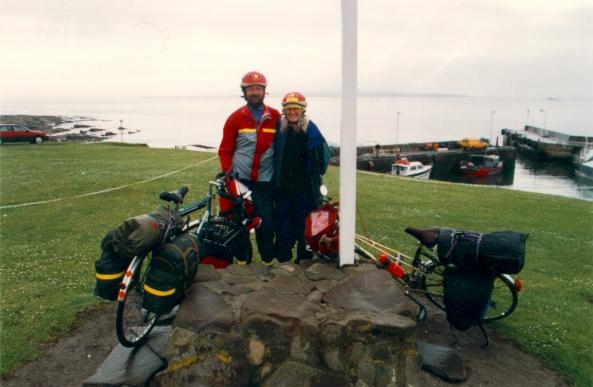 Finished